Age verification
Are you 18 years of age or older?
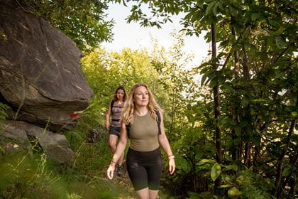
Hiking on the Niederhorn
Across lush mountain meadows, through romantic moorland and sparse fir forests – hiking on the Niederhorn is full of unique natural experiences.
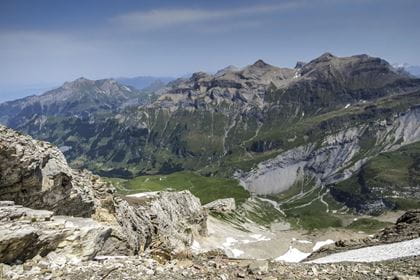
Alternatively, you can explore on foot using the more than 120 km of hiking and Alpine trails. You can therefore wander over meadows and through forests while breathing in the mountain air and enjoying the views over Lake Thun and peaks that are topped with snow all year round. Nature fans will be in their element thanks to the high moorland of national significance, the Karst limestone areas, and the protected flora, including crocuses, Alpine roses and edelweiss. The area is home to a rich array of wildlife and encounters with ibexes, marmots or golden eagles are not uncommon.
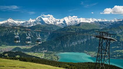
The Niederhorn is very easy to reach by public transport. Travel in comfort by train, bus or boat to Beatenbucht and onwards with the funicular and group gondola up to the summit.
Hiking routes
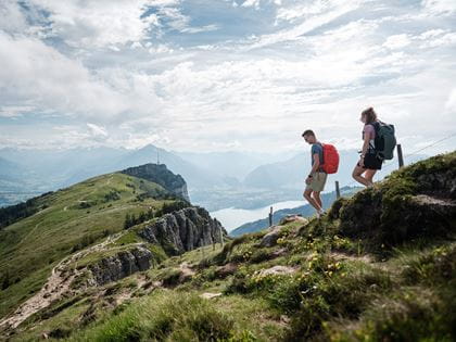
Pack your rucksack and lace up your hiking boots
On the Niederhorn, 120 km of marked and well-maintained hiking trails await you, with something for every level and preference. Would you like to venture on a high-altitude hike with a great view, climb to the summit from the valley or take a leisurely stroll with the kids? Pack provisions and enjoy the numerous idyllic picnic and barbecue spots along the trails. And stay alert, because you might spot curious marmots, shy deer or stately ibexes.

Niederhorn–Beatenberg, 2 hrs
A hiking experience for young and old
The hike from the Niederhorn to Beatenberg is a classic. The first stretch runs above the tree line and offers a magnificent view of Lake Thun. Before the Flösch alpine pasture becomes visible, a path branches off eastwards in the direction of Häliloch-Oberburgfeld. Anyone who is interested in high moors should take a detour here to Flöschseeli, five minutes away, which lies in the middle of the high moor. Numerous picnic areas and fire pits are at your disposal and, if you are lucky, you will encounter eagles, chamois or deer.
| Hiking route | Niederhorn–Flösch–Vorsass–Bodenalp–Riedboden–Beatenberg Station |
| Distance | 5.3 km |
| Hiking time | 2 h |
| Height difference | 840 m |
| Level of difficulty | medium |
Niederhorn–Habkern, 3 hrs 45 min
The most beautiful hiking trail in Switzerland
The hiking route from the Niederhorn to the Gemmenalphorn was awarded the gold medal for the most beautiful hiking trail in Switzerland. The first part of the hike runs above the tree line and offers a breathtaking view of Lake Thun and the mountain massif of the Eiger, Mönch and Jungfrau. Up to the small Hohseil-Seeli lake, the path is nicely flat and even just the walk up to here and back is an experience.
Then follows the ascent to the Burgfeldstand, the highest point of the hike. Here eagles or bearded vultures circle, and further along the route to the Gemmenalphorn you cross the territory of ibexes and ptarmigans. On the Gemmenalphorn, enjoy the unobstructed view of the Sieben Hengste, the Hohgant and the entire Seefeld area. The path then leads steeply downhill to Seefeld Oberberg, passing the karst area. Those who want to can make a short detour here and hike eastwards along the alpine huts to the limestone pavements (about 15 minutes each way). Via the alpine pastures of Schwendli and Chromatte, the path leads into the dense forest and on to the first hamlets of Habkern. In the mountain village you can have a snack and take the post bus to Interlaken.
| Hiking route | Niederhorn–Burgfeldstand–Gemmenalphorn–Habkern |
| Distance | 10.7 km |
| Duration of the hike | 3 h 45 min |
| Difference in altitude | 1200 m |
| Level of difficulty | medium |
Niederhorn–Waldegg, 3 hrs
Over hill and dale with alpine views
The first section of the hike runs above the tree line and offers a breathtaking view of Lake Thun and the mountain massif of the Eiger, Mönch and Jungfrau. The path is flat until you reach the little Hohseil-Seeli lake, where you’ll often find mountain newts that you can observe easily.
Far away, you can see the alpine huts on the Oberburgfeld. From July to August there are occasional simple catering facilities there and you can watch the alpine dairyman making cheese. The route continues on towards Gemmenalp Oberberg, where there is also an alpine hut, and with a bit of luck, you’ll be able to watch the marmots playing on the ground in front of it. Now the path runs across alpine pastures down towards Waldegg. From the Chüematte the path leads through denser forest to Hohwald, where you again have a clear view of the Alps. The last stretch leads to the Waldegg district, where there are restaurants, hotels and the post bus back to the valley station of the Niederhornbahn or directly to Interlaken.
| Hiking route | Niederhorn–Oberburgfeld–Oberberg–Waldegg |
| Distance | 8.6 km |
| Duration of the hike | 3 h |
| Difference in altitude | 880 m |
| Level of difficulty | medium |
Niederhorn–Haberelegi–Beatenberg, 2 hrs
In the shade of the trees, on the soft forest floor
This hiking trail leads quite steeply downhill and runs mostly through the forest. If you take a rest on a wooden bench in the upper section and unpack your backpack, you will probably find yourself surrounded by mountain gods, who will even steal your picnic from your hands. If you are lucky, you will see an eagle or a bearded vulture exploring from the air or encounter chamois, foxes or even deer.
| Hiking route | Niederhorn–Haberelegi–Beatenberg Station |
| Distance | 4.2 km |
| Hiking time | 2 h |
| Height difference | 830 m |
| Level of difficulty | medium |
Niederhorn ridge trail, 30–40 min
Marvel and learn
Go on a «ridge walk» and enjoy the breathtaking panorama, the tingling in your legs when you look over the steep rock faces down into the Justistal valley, and the fantastic view of the Eiger, Mönch and Jungfrau in the distance. Here, thrills, a panorama and untouched nature combine to create an incomparable experience. Information boards along the ridge trail provide a wealth of information about the mountain and alpine world as well as flora and fauna.
| Route | circular trail along the Niederhorngrat |
| Distance | ca. 600 meters |
| Hiking time | 30–40 minutes |
| Level of difficulty | easy to walk, partially asphalted and accessible with a stroller |
| Highlight | spectacular rock bridge |
| Special | 9 creative info points about flora & fauna viewing platforms with benches and panorama boards |
BLS suggestion


Operating hours Today (Sunday) open
The Niederhornbahn services run every day from 1 May to 15 November 2026.
Rates
Walker’s ticket Beatenbucht–Niederhorn / Vorsass–Beatenbucht
- CHF 57.30 Adults
- CHF 28.70 With Half-Fare travelcard
- CHF 21.80 GA
- CHF 28.70 Children aged 6 to 15.99
Walker’s ticket Beatenberg–Niederhorn / Vorsass–Beatenberg
- CHF 43.60 Adults
- CHF 21.80 With Half-Fare travelcard/GA
- CHF 21.80 Children aged 6 to 15.99
With the walker’s ticket, you can ride 3 sections and walk 1 section.
Children: You pay only for the first child (up to 16 years) in the family, each additional child rides free. This offer also applies to scooter rental.
The ticket for dogs costs CHF 5.00. Dogs must be kept on a leash.
Prices in CHF incl. VAT / Prices and products subject to alteration.
Food & Drink
Berghaus Niederhorn
Finish your excursion to the Niederhorn with a visit to the Berghaus restaurant. The Berghaus also offers accommodation in small but perfectly formed rooms with a unique panorama over the Bernese Alps.
Bärgrestaurant Vorsass
Take time for a breather. Enjoy traditional and down-to-earth dishes on the sun terrace or in the cosy dining room.
Picnic
There are numerous beautiful places along the hiking trails for a good picnic. Several fire pits are also available for barbecuing. If you wish, you can hire a fondue backpack and enjoy a delicious fondue in the middle of the magnificent mountain landscape (by prior arrangement).
How to get there
- Timetable & tickets to Beatenberg


Location
Contact
- Niederhornbahn AG
- +41 33 841 08 41
- Niederhornbahn www.niederhorn.ch