Skip to content
Back
Home
Timetable & Tickets
Navigation
Contact
Travel
Back
Travel
Learn more
Timetable
Back
Timetable
Learn more
Current operating situation
Printable timetables
BLS lines
Advice for your journey
Tickets
Back
Tickets
Learn more
Travelcards
Tickets
Sales
Travelling for less
Passenger information
Back
Passenger information
Learn more
Travellers with disabilities
Travelling with children
Travelling with bicycles
Travelling with dogs
Car transport service
Back
Car transport service
Learn more
Kandersteg–Goppenstein
Brig–Iselle
Kandersteg–Iselle
Leisure
Back
Leisure
Learn more
Excursions
Back
Excursions
Learn more
Experience & discover
Get active
Indulgence
Events
Back
Events
Learn more
Events calendar
Public and private group tours with BLS
Holidays
Back
Holidays
Learn more
Advice
Additional services
Navigation
Back
Navigation
Learn more
Fares & season tickets
On-board experiences
On-board catering
Charter
Back
Charter
Learn more
Train rental
Bus rental
Boat rental
Services
Back
Services
Learn more
Before your journey
Back
Before your journey
Learn more
Buy a ticket
Class upgrade
Luggage service
During your journey
Back
During your journey
Learn more
Upgrade during pregnancy
Bistro offer on board trains
Conductors
After your journey
Back
After your journey
Learn more
Lost Property Service
Passenger rights
Customer service
At our stops
Back
At our stops
Learn more
Travel Centre
To & from the train station
Parking at the station
Company
Back
Company
Learn more
Jobs & Career
Back
Jobs & Career
Learn more
Job vacancies
Further training
Apprenticeships
Work placements and dissertation projects
About us
Back
About us
Learn more
Who we are
Responsibility
Fleet
BLS Inside
Media
Back
Media
Learn more
Media releases
Ad hoc announcements
Media library
Photo shoots and videos
Our topics
Back
Our topics
Learn more
Werkstätten
Lötschberg
Construction work
Development projects
Third-party business
Back
Third-party business
Learn more
Supply Chain Management
Services
Properties
Infrastructure
Navigation
Travel
Timetable
Current operating situation
Printable timetables
BLS lines
Advice for your journey
Tickets
Travelcards
Tickets
Sales
Travelling for less
Passenger information
Travellers with disabilities
Travelling with children
Travelling with bicycles
Travelling with dogs
Car transport service
Kandersteg–Goppenstein
Brig–Iselle
Kandersteg–Iselle
Leisure
Excursions
Experience & discover
Get active
Indulgence
Events
Events calendar
Public and private group tours with BLS
Holidays
Advice
Additional services
Navigation
Fares & season tickets
On-board experiences
On-board catering
Charter
Train rental
Bus rental
Boat rental
Services
Before your journey
Buy a ticket
Class upgrade
Luggage service
During your journey
Upgrade during pregnancy
Bistro offer on board trains
Conductors
After your journey
Lost Property Service
Passenger rights
Customer service
At our stops
Travel Centre
To & from the train station
Parking at the station
Company
Jobs & Career
Job vacancies
Further training
Apprenticeships
Work placements and dissertation projects
About us
Who we are
Responsibility
Fleet
BLS Inside
Media
Media releases
Ad hoc announcements
Media library
Photo shoots and videos
Our topics
Werkstätten
Lötschberg
Construction work
Development projects
Third-party business
Supply Chain Management
Services
Properties
Infrastructure
en
de
fr
it
en
Contact
Excursions
Your next excursion with BLS
Excursions
Your next excursion with BLS
Excursions
Your next excursion with BLS
Excursions
Your next excursion with BLS
Filter entries
Time
Location
Category
From
To
The date must be a maximum of 365 days after the start date.
Reset filter
Apply
Position
Please select a radius
5 km
10 km
20 km
30 km
40 km
50 km
Berne
0
Bernese Oberland
0
Emmental & Oberaargau
0
Entlebuch & Willisau
0
Three-Lakes & Jura
0
Upper Valais
0
Piedmont
0
Others
0
Reset filter
Apply
Bikes & e-bikes
0
Viewing points
0
Swimming & wellness
0
Railway adventures
0
In all weathers
0
Stage & sound
0
Family
0
Guided tours
0
Food & drink
0
Trade fairs & festivals
0
Leisure activities
0
Groups & schools
0
Lakes & boats
0
Special offers
0
Sport
0
Hiking & nature
0
Knowledge & culture
0
Webshop
0
Reset filter
Apply
{total} Entries
Filter
Display more
Discover
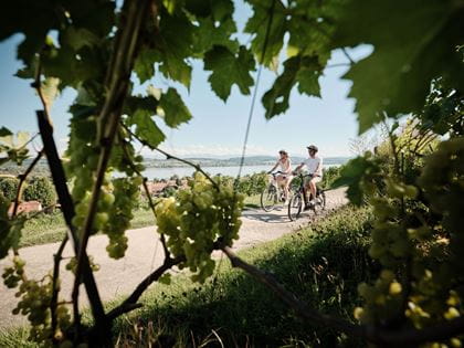
Cycling tours in the Lake Murten region
Discover the Three Lakes Region on your bike
Experience
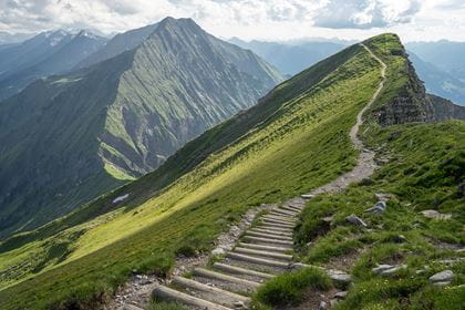
Niesen – the mountain for hikers and athlete
The Niesen (2362 metres above sea level) is one of the most famous peaks in the Bernese Oberland – not least due to its pyramid shape and its wonderful location high above Lake Thun.
discover
Tickets
Travel at best prices
Supersaver tickets
up to 50% off
Saver Day Pass
Excursion Passes
Berner Oberland Pass
Matterhorn Gotthard Pass
Lucerne Travel Pass
BLS Travel Centre
Start your journey the easy way at the BLS Travel Centre.
more
Events
Calendar of Events
discover
Breadcrumbs
Home
Leisure
Excursions
Newsletter
Subscribe
View in browser
Download PDF
0
of
0
Media files