Age verification
Are you 18 years of age or older?
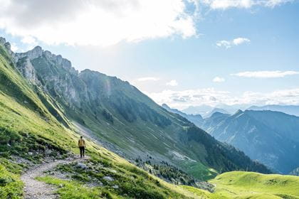
Stockhorn – the hiking paradise in the Bernese Oberland
Discover the enchanting mountain lake and the various hiking trails for all tastes
Welcome to the Stockhorn region, where a variety of hiking trails – from relaxed walks to challenging mountain tours – await you.
Enjoy the unspoilt idyllic environment and nature of the Stockhorn and the panorama of the Swiss Alps up close and experience an unforgettable day full of adventure and relaxation. Whether sunbathing on the panoramic terrace, hiking on one of the many hiking trails, or even bungee jumping – the Stockhorn offers the right experience for all guests!
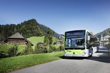
Tip: Travel by public transport and benefit from our special "Gurnigel-Stockhorn hiking ticket" offer. This makes your trip to the Stockhorn an inexpensive and environmentally friendly experience.

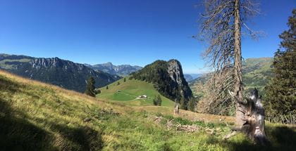
Hiking trails in the Stockhorn area
Hiking routes for every taste
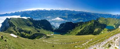
In the heart of the Swiss Alps, the Stockhorn region offers a wealth of hiking and walking opportunities for all levels of experience and skill. Whether you prefer a leisurely hike around the idyllic Hinterstockensee lake on the barrier-free «No Limits – Circular Lake Trail» or are looking for the challenge of the Strüssligrat – all hiking fans will get their money's worth here! The quiz trail turns hiking into an exciting experience for young explorers, while the adventure trail introduces people of all ages to the flora and fauna of the Bernese Oberland. And if you want to make your journey back down into the valley a special experience, you can hire a scooter bike from Vorderstockenalp and watch the fantastic landscapes pass by.
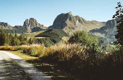
Stockhorn–Stockenfeld–Oberstockenalp
The classic

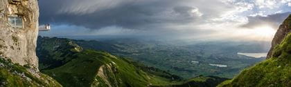
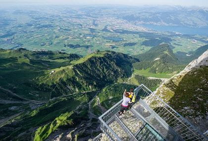
The starting point of the hike is the Stockhorn mountain station. Once there, you should definitely make a detour to the panoramic viewing platform on the north face of the Stockhorn. Here you can enjoy a breathtaking view from Lake Thun to Jura. On clear days, the view even extends as far as Alsace and the southern Black Forest. You can also top up your energy levels before the hike in the Stockhorn panoramic restaurant.
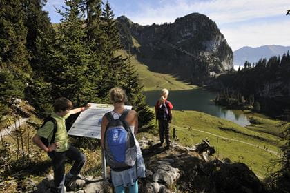
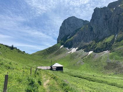
With views of over 200 mountain peaks from Titlis to Moléson, the hiking trail leads from the Stockhorn via Stockenfeld to Oberstockenalp. Oberstockenalp is both an alpine dairy and a restaurant. Enjoy a break on the wonderful sun terrace or in the cosy restaurant. If you like, you can take a detour from here to Oberstockensee lake.
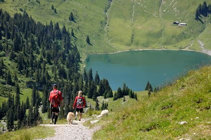
The trail now leads through a sparse fir forest and past karst fields down to the idyllic Hinterstockensee lake. Benches by the lake invite you to linger just that bit longer. Next, the trail leads a short way up to the Chrindi middle station, where you can stop off at the Chrindi restaurant before taking the cable car back down to Erlenbach i.S.
Key data
| Route | Bergstation Stockhornbahn–Stockenfeld–Oberstockenalp–Mittelstation Chrindi |
| Distance | 3.4 km |
| Walking time |
1 hour 10 minutes |
| Elevation difference |
Ascent: 45 m Descent: 545 m |
| Level of difficulty | medium |
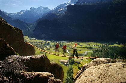
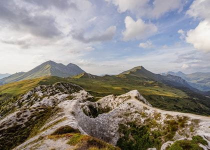
Stockhorn–Strüssligrat–Oberstockenalp
For those with a head for heights

This route offers an interesting alternative for sure-footed hikers with a head for heights.
Key data
| Route | Bergstation Stockhornbahn–Strüssligrat–Oberstockenalp |
| Distance | 4.6 km |
| Walking time |
1 hour 10 minutes |
| Elevation difference |
Ascent: 105 m Descent: 612 m |
| Level of difficulty | difficult |
Oberstockenalp–Hinterstockensee–Chrindi
Leisurely hike

A leisurely hike through the forest down to the Hinterstockensee lake.
Key data
| Route | Oberstockenalp–Hinterstockensee–Mittelstation Chrindi |
| Distance | 4.6 km |
| Walking time |
approx. 50 minutes |
| Elevation difference |
Ascent: 52 m Descent: 358 m |
| Level of difficulty | medium |
Stockhorn–Chummli–Oberbärgli–Chrindi
A route off the beaten track

A less-frequented trail with spectacular views.
Key data
| Route | Bergstation Stockhornbahn–Chummli–Oberbärgli–Mittelstation Chrindi |
| Distance | 2.7 km |
| Walking time |
1 hour 10 minutes |
| Elevation difference |
Ascent: 38 m Descent: 542 m |
| Level of difficulty | medium |
Chrindi–Chlusi–Erlenbach
Direct descent into the village
This route leads from the Chrindi middle station down to the village of Erlenbach i.S.
Key data
| Route | Mittelstation Chrindi–Chlusi–Erlenbach i.S. |
| Distance | 4.1 km |
| Walking time |
2 hours |
| Elevation difference |
Ascent: 4 m Descent: 921 m |
| Level of difficulty | medium |
Alpine flowers nature trail


On a short walk from the Stockhorn mountain station to the summit, you can explore the beautiful flora of the Stockhorn area. Around 95 different plant species can be found on the summit trail. Each species is labelled with a yellow name tag. A feast for the eyes, even for people who aren't flower enthusiasts. Every spring, the nature trail is redesigned, and the nameplates are redistributed. New plants are also featured, which were not there the previous year.
Key data
| Route | Bergstation Stockhornbahn–Stockhorngipfel |
| Distance | 0.2 km |
| Walking time |
7 minutes |
| Elevation difference | 50 m |
| Level of difficulty | easy |
The book «Die bunte Pflanzenwelt des Stockhorngebietes» (The colourful flora of the Stockhorn region) by W. Strasser is available for CHF 10.00 at the valley station.
Adventure Trail
Discover habitats
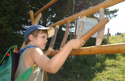
Educational hike for young and old
Inhale the scents, hear the bird calls, and read the tales – on the Adventure Trail you will discover the habitats on the Stockhorn.
The Adventure Trail consists of 16 stations along the circular route around the two Stockensee lakes. Independent exploration and experience, enjoyment and pleasure are the main focus here. The path takes you from the middle station at Chrindi along well-maintained hiking paths to Oberstockenalp, the Oberstocken Lake and back via Vorderstockenalp to the starting point of Chrindi.
Key data
| Route | Mittelstation Chrindi–Oberstockensee–Chrindi |
| Distance | 6.6 km |
| Walking time |
2 hours 15 minutes |
| Elevation difference | Ascent: 388 m Descent: 389 m |
| Level of difficulty | easy |
A 70-page accompanying brochure produced by the University of Bern offers you background information on the individual topics. This and an overview map are available free of charge at the Stockhornbahn cable car.
No Limits
Barrier-free circular route

The «No Limits» hiking trail that leads around the Hinterstockensee lake was designed to be accessible for wheelchairs and pushchairs. This way, people with restricted mobility can likewise enjoy the landscape unhindered.
Four electrically powered, all-terrain «Mountain Drive» wheelchairs can be hired for CHF 25.00 from the Chrindi middle station. An intelligent chassis with electric drive ensures that the wheelchair can be manoeuvred safely off-road. The driver must be able to switch over to the wheelchair independently or be assisted by a trained attendant. Stockhornbahn staff are not permitted to help people into the wheelchair. The driver must also be familiar with handling joystick-controlled wheelchairs.
Trail no. 8, the Hinterstockensee circular trail, is wheelchair-accessible. The circular route has some areas that are challenging for wheelchairs and require careful manoeuvring.
You overcome a height difference of +- 85 metres and pass through two tunnels and over a bridge. The trail must be travelled in an anti-clockwise direction.
Key data
| Route | Mittelstation Chrindi–Hinterstockensee–Mittelstation Chrindi |
| Distance | 2.6 km |
| Walking time | 50 minutes |
| Elevation difference | 75 m |
| Level of difficulty | easy |
| Path types | Gravel path: 0.3 km Nature trail: 1.8 km Path: 0.5 km |
Please note: The «No Limits» circular lake trail should only be attempted with the «Mountain Drive Stockhorn» special wheelchairs. We strongly advise against travelling with your own wheelchair for safety reasons.
Quiz-Trail
Family-Tip


Hike with children and solve the fun puzzle
There are 10 posts along the circular lake trail where letters are hidden. At the end of the quiz, you should hopefully have the word that is the solution. Just like a treasure hunt, there are all sorts of adventurous things to discover along the way. All of a child's senses and natural curiosity are awakened on this diverse trail. They can climb, play and romp along the way.
The booklet for filling in the solution is available in the brochure stand at the valley station.
Key data
| Route | Mittelstation Chrindi–Hinterstockensee–Mittelstation Chrindi |
| Distance | 2.6 km |
| Walking time |
50 minutes |
| Elevation difference | 75 m |
| Level of difficulty | easy |
Stockhornbahn operating times Today (Wednesday) open
The Stockhornbahn cable car will take you up to the Stockhorn summit every day from 11 April to 22 November 2026. The cable car runs every 30 minutes. The cable cars and post buses run daily and offer you flexible travel options:
- First journey: from 07.50 hours
- Last journey to the summit: 16.35 hours
The following options are available for your return to the valley after a fulfilling day of hiking:
- Last descent from Stockhorn: 17.35 hours
- Last descent from Chrindi: 17.50 hours
So that you can enjoy a carefree day on the Stockhorn and don't miss the last descent, we recommend that you plan your return journey using the timetable.
Subject to change without prior notice
Rates
Stockhornbahn Erlenbach–Chrindi return (middle station)
- CHF 44.00 Adults
- CHF 22.00 Adults with Half Fare Card
- CHF 22.00 Adults with GA
- CHF 22.00 Children (6–15.99 years)
- free of charge Children up to 5.99 years
Stockhornbahn Erlenbach–Stockhorn return (summit station)
- CHF 62.00 Adults
- CHF 31.00 Adults with Half Fare Card
- CHF 31.00 Adults with GA
- CHF 31.00 Children (6–15.99 years)
- free of charge Children up to 5.99 years
Prices in CHF incl. VAT / Prices and products subject to alteration
Food & Drink
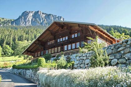
- Stockhorn panorama restaurant modern summit restaurant
- Restaurant Chrindi at the middle station
- Berggasthaus Oberstockenalp homemade cheese specialities
BLS suggestion High-altitude hike Gantrisch–Stockhorn
Are you familiar with the «Gurnigel-Stockhorn» hiking ticket?
Experience one of the most spectacular high-altitude trails in Switzerland with our special «Gurnigel-Stockhorn hiking ticket» offer, with which you can enjoy an eventful journey from the Gantrisch region to the imposing Stockhorn summit. Marvel at breathtaking panoramic views over the Bernese Alps, Lake Thun and the picturesque Simmental valley as you hike along the striking Gantrisch range.
The hiking ticket includes the journey on the post bus journey as well as the descent on the Stockhorn cable car at an attractive price. Take the train to «Thurnen» train station, where you change to the post bus at 08.35 hours and are taken directly to the starting point of your hike «Gurnigel, Wasserscheide».
How to get there


Location & contact
Contact
- Stockhornbahn AG
- +41 33 681 21 81
- Stockhornbahn www.stockhorn.ch